• The SH Membership has gone live. Only SH Members have access to post in the classifieds. All members can view the classifieds. Starting in 2020 only SH Members will be admitted to the annual hunting contest. Current members will need to follow these steps to upgrade: 1. Click on your username 2. Click on Account upgrades 3. Choose SH Member and purchase.
  • We've been working hard the past few weeks to come up with some big changes to our vendor policies to meet the changing needs of our community. Please see the new vendor rules here: Vendor Access Area Rules

Cyber Scouting - ISO Advice

NorthWoodsNovice

New Member
Joined
Nov 16, 2021
Messages
17

The setup - Midwest Ag - Private 40 acres​


I'm not sure if this is the right forum, but I'm looking for some cyber scouting help on a friend's private agricultural ground here in the Midwest. I'm planning to hunt 2.5 days on it in mid-October. I'm a young father of three, so my time is limited and my goal is simple: fill the freezer. I'd gladly take a big doe or a buck, but I'm not picky.

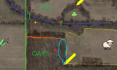
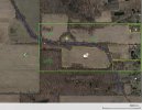
The map:
  • Green outline — my friend's farm, roughly 60 acres, only 40 of it huntable.
  • Yellow shading — off limits. Either the neighbor's ground or currently holding livestock.
  • Red dots — permanent stands. My friend has killed six deer off these locations in the last three years.
  • Green lines — known creek crossings, ankle deep, where we've watched deer cross.
  • Yellow dots — my sits and finds from last year (referenced below).
  • Corn icon — standing corn, but note it's the neighbor's field, off my west line.
  • Clover icon — small clover patch.

My friend asked that we stay off the neighboring property lines. Good fences, good neighbors. We can track a deer across a line if we have to, but only if it's necessary.

The short version of the layout: there is an abundance of food on or near the property. There's the neighbor's standing corn off my west line, there's other mixed ag north and west of the property, and there is a great oak flat on my neighbor's property (main red dot in the middle). I think that there is bedding on both north and south of the property on the neighbors' ground off my south line. Hay was cut late June and a patch of clover in the middle there.

Last year: 1.5 days, mid-October​

Total: 16 deer seen or encountered in two days. I grew up rifle hunting near the Canadian border in Minnesota, so this kind of deer density is unbelievable.

Morning 1. I put a buddy who's new to hunting in the ladder stand at the creek crossing and set my saddle in a nearby tree. We were quiet and settled 30 minutes before light. A deer across the creek scented us and blew out anyway — sounded like a doe and a fawn, but we never laid eyes on them. Light westerly wind, so my guess is the creek bottom gets swirly. Later I watched a young buck cross the hay field 150 yards to the north, headed back toward bedding.

Afternoon 1. I set up at the yellow dot on the little peninsula in the northwest hay field. We took a heavy rain — absolutely drenched in a thunderstorm — that cleared up about an hour before sunset. Right after it broke, a young buck crossed the hay field diagonally moving south toward the corn, but stayed beyond my effective bow range (35 yards). A doe and fawn came south down the property line of the NW hay field but never worked out to the peninsula. Just before dark I had a big buck on the north edge of the field at 100 yards, but couldn't grunt or call him in.

Morning 2. My buddy and I both set up in the Oak stand (seasonal hang-on). Quiet 60 minutes before light. Something followed our trail in — maybe a small deer — but left before shooting light. Thirty minutes after sunrise, nine deer moved through the woods 100 yards south of us, coming off the corn and headed to bedding on the neighbor's property. That puts them right on the south property line.

Scouting my way out that morning, I found a massive rub line south of the creek at the yellow dot, close to the second creek crossing nearest the west property line. For what it's worth, there's also some nighttime activity around the clover patch, but I didn't find as much sign there.

This year's plan: 2.5 days, mid October​

My friend wants to sit the permanent Oak stand (accessing from the south property line). My tentative plan is to hunt the rub line at the yellow dot on my first morning. Access would be walking west along the hay field, dropping into the creek bed at the first crossing, then climbing up within range of the rubs and the second crossing.

Where I need help​

  1. What am I missing?
  2. Without a steady breeze, is that creek bottom too swirly to hunt on a quiet morning?
  3. Am I overthinking this? Again, I am relatively new to archery hunting, so closing that effective range is my biggest challenge right now.
Happy to answer questions about the layout. Thanks for any help!
 

Attachments

  • Farm Scouting.jpg
    Farm Scouting.jpg
    169.6 KB · Views: 36
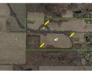
I like the spots indicated by the yellow arrows. The top one is a pinch formed by the Y shaped intersection of what looks like a creek. The bottom left is an inside corner of a field in the woods. Anything wanting to move in cover will likely cut that corner. Arrow off to the right is close to that creek crossing (if I am understanding the map legend correctly). That spot also looks to be a good travel corridor north to south and east to west at the crossing. Those are just the spots I'd pick to check first if I had never set foot there before and was planning a hunt.
 

Attachments

  • spots.jpg
    spots.jpg
    179.8 KB · Views: 24
I assume this is a bow hunt.

MAJOR Q;;; Is the rubline mentioned above leading to the fields, or is it leading to the oaks/down the creek ...

If there is any indication that bucks bed on the eastern portion of the property or southeastern on the neighbor ..

With only 2.5 days to hunt I would spend my entire first day sitting the eastern-most creek crossing between the two off-limits fields, or close to the crossing. DAY ONE MARATHON SIT is observation. You can weather an easterly or westerly wind for this education, so you have that going for you, which is nice.

OIP.RiR_NVQV1uD_rP9B7rMHJQAAAA


IF no good vibes from DAY ONE, and the rub line leads away from the fields, MORNING TWO I would hunt the middle creek crossing in the AM and the yellow mark of the rub line in the PM.

If my half day is the last morning, I'd cross my fingers, HOPE AGAINST HOPE, and sit the yellow rub dot very early with a capital F until about 9 if the corn is still standing, then still hunt whichever way depending on the wind until the whistle blows.

HOPE YOU GET GOOD WINDS FOR THIS PROPERTY, AND THAT AM VS. PM PROBABILITIES LINE UP.
 
Thanks guys!
One clarification - the White creek crossing (furthest east) on my map is a man-made bridge of simple timber. It is used almost daily by my farmer friend, and I didn't see any obvious deer sign that it was used heavily by deer. Sorry for not communicating that earlier.

@NMSbowhunter, The top of Y is a good idea. It is an old drainage, with no running water, but there are a lot of pieces coming together there. It might be a good afternoon sit.

@HuntMeister, great idea on the cut clover. Last year, the farmer did not regularly cut it at all. I don't know hunting farmland well so those types of tips are gold for me right now.

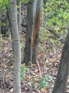
@Swamp Fox__On The Run, the rubline was leading from the western corn toward the NW hay field / creek crossings. There were a few shin high rubs on saplings, but then this big one caught my eye. Volleyball sized trunk, rub up to my waist (on October 13th). Again, I am not targeting big bucks, but I wouldn't pass one either.

1788397857023.png
 
I think you want to investigate that eastern pinch point between the off-limit fields to see if it needs eliminating. Cameras in advance of the hunt could save an all-day observation sit, if you prefer to go that route. But just because you don't see a lot of sign in mid-October doesn't mean a buck isn't funneling through it. Keep an eye out for sign farther south//southeast.

My concern is that AM deer are off the fields and deep in the woods before you even get set up. Then I'm not sure you have stealthy access to where you need to be in the PM. The plan I outlined above is to dial into them without blowing them out, hopefully with a westerly/northerly wind.

Re rubs ... Bucks are either bedding or feeding in the corn, or both, based on your description. That's a tough situation.

Q;; Will the corn be standing at the time of your hunt ...
 
First, let me preface this by saying I'm not all that good at cyberscouting . . . I need to put boots on the ground when scouting for me to be successful. I like the suggestions put forth by @NMSbowhunter . That said, I notice that the tree line to the north of the oaks appears different, (i.e. pines, taller trees, a little thicker . . .) to me that's a transition. I would look just south of that transition for a trail running parallel to it following the transition. This is especially true close to the corn field where the deer will enter/exit it.

Second spot I notice and would look at is the western edge of the sheep field. Typically these edges grow thicker due to the increased sunlight in the area. This might be a good bedding spot for deer feeding on the corn. A prevailing westerly wind blows scent through the oaks covering what they can't see and they can look across the open field for danger approaching from downwind. It also puts them walking into the wind to go feed.

The one thing I don't know is which direction the water in the creek runs. I will say in my experience, once the prevailing wind starts to die down the creek seems to draw the air along the moving surface a lot like a thermal flowing downhill. Just one more thing to keep in mind for your setup.

1788438082336.png
 

Thank again for all of the help guys!​

@Swamp Fox__On The Run,​

The Corn will still be standing in October. I've seen most morning activity moving away from the westerly corn/agriculture towards bedding north and south of the property.

@boyne bowhunter​

I like your thinking with edge bedding in the oaks.
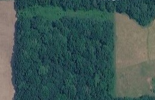
Here is another satallite image with leaf cover of the Oak flat.
There is a strip of treeless tall grasses to the north of the Oaks before the creek bottom. Mainly Cottonwood trees on the creek.
I agree that eastern edge of the Oaks is potential bedding too, but near impossible to access without spooking them. I guess the play would be getting in super early and beating them back to their beds.

Also, great point about the thermal pull. The creek moves East to West. Another reason why I think that my scent got swirly with a light westerly wind. Thermals pulling towards the West + prevailing westerly Wind = Swirl city.
1788483574977.png
 
Last edited:
Back
Top