• The SH Membership has gone live. Only SH Members have access to post in the classifieds. All members can view the classifieds. Starting in 2020 only SH Members will be admitted to the annual hunting contest. Current members will need to follow these steps to upgrade: 1. Click on your username 2. Click on Account upgrades 3. Choose SH Member and purchase.
  • We've been working hard the past few weeks to come up with some big changes to our vendor policies to meet the changing needs of our community. Please see the new vendor rules here: Vendor Access Area Rules

Please help me understand maps better

MIPublic

Well-Known Member
SH Member
Joined
Oct 5, 2020
Messages
1,009
Location
SW MI
So despite my handle, I'm fairly new to public land. I use it a lot for squirrel hunting with my young dog, but all of my deer to date have been on private land. My goal is to change that this year. I'll likely still get a private land deer or two but my goal is to spend more and more time on public. With that, I'd like to get better at scouting maps and then putting boots on the ground to confirm and find even better spots. I'm not looking for anyone to give me the answers to everything, but I'd like some help to point me in the right direction on what exactly I'm looking at, and for. I've watched the THP videos on picking apart maps, but I'm still struggling. I know fresh sign when I see it, but I feel like I'm stumbling upon it more than I'm finding it successfully.

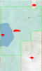
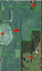
I'm looking for assistance on the map below. It's public land and a plot that I've not hunted, set foot on, or even laid eyes on. I picked this one as an example as there is varying terrain, a water source, some open fields, and different trees. It's a good representation of what we'd find all over Michigan until you get to the UP. I'd like, if anyone is willing to share, their thoughts on potential setup spots and what I'm looking at. My goal in this is to take this knowledge and begin to transition it to other new plots, and even the existing state land that I hunt to have more success.

Thanks everyone!

PS - In case anyone is unfamiliar with OnX, the light green area is fair game, the section in the bottom right and the little section near the top right, is private land. This chunk of public is about 200 acres. The bottom right private chunk is 80ish and the top right little private spot is 5, just for reference.
 

Attachments

  • Topo view.PNG
    Topo view.PNG
    697.3 KB · Views: 85
  • satalite view.PNG
    satalite view.PNG
    1.2 MB · Views: 85
Last edited:
From what I'm seeing Lets start with the sat. image. On the lower right It looks like there are already a few trails on the private land. Also it looks like right above the private land where the public land borders it, It looks like it might be an older clear cut that has grown up a bit. That would be a good spot for potential bedding. I would look into that area. Look at the possible bedding area itself, See how its got a hard transition line of different veg? I would walk that and look for any sign. I would also go to the water source and walk it looking for sign. Look for normal food source and bedding in between. I hunt public land and its a huge national forest, about 300,000 acres. There are multiple tracts to choose from. So what I is pick a tract of land that's about 100 to 200 acres. I mark that with an outline on OnX map. Then I look for easy access points then mark those. Thats where I start. I then drive to those easy access points and put boots on the ground. What I'm looking for first is sign left from hunters. Stands, scent wicks ECT. I mark all those areas that I find . I start looking for Transition lines of veg, game trails, any deer sign . Food, water and bedding. IF I have to I take the big chunk of land and break it down into smaller chunks and focus on where a deer might move to feel safe. Also check you topo lines look for saddles , ridge lines or valley's . Check the points on ridges where you have elevation change . scout there to look for bedding. . But like i was saying, Brake it down into smaller chunk that are easy for you to walk and systematically walk it . drop pins Where you find sign and make notes. I even take pictures. and add it to OnX to review later when at home. Make sure to sync ONX on a computer so you can pull it up when at home. it really helps. This method my take several trips to scout the whole area but it's worth it in the long run. Ill post some more tips on what I see on your pics and mark some things for you later.
 
So maybe this will help, maybe not, but this is what I do, and I spend many nights staring at maps of country I hunted with success and new spots.
#1 Looking at a zoomed in picture of a map of such a small piece of property does nothing for me, I know nobody wants to give away where they are hunting so that’s why they do it and I don’t blame them one bit, but in all honesty any help somebody can give by looking at that map is gonna be a crap shoot at best, just my honest opinion. I look at the big picture, and then go from there, several miles, I realize hunting public is what it is but I am still using my map skills to cyber scout the private that I can’t hunt and using that in relation to what public I start with. I can’t tell from a picture that zoomed in if there is a 30 acre bean field a 1/4 mile west or major city.
#2 Once I have narrowed down the public pieces I am going to scout, after many hours of cyber scouting the private I can’t hunt, boots on the ground, marking everything as I scout, what may be insignificant at the time, later mite be important, a rub here or there may help you connect the dots once your home and back to cyber work again. You can always delete waypoints after the fact but it’s tough to create them again from the couch is my theory, and I always try to label them in the field so I know what the heck they are later that night or when I study my new map.
#3 A great book that explains in detail the basic fundamentals of map reading is “Mapping Trophy Bucks” by Brad Herndon, somebody actually just gave one away on here today, anyways it’s a great read and well worth the investment, he explains in detail, saddles, pinch points, that sort of thing, which is key to finding rut hubs and other stuff on maps.
#4 If you get snow, there is absolutely no better time to scout, let the tracks tell the story, if your deer herd migrates during the winter and floods areas that are usually devoid of deer please keep that in mind, but for the most part a saddle is a saddle and so on, so if deer are there (the area you are scouting) more heavily in the winter than normal, they will still hammer the same pinch points and runways which will be used by the local deer that live there all year.
#5 Boots on the ground, when hammering away scouting keep in mind some of your best rut funnels and pinch points will still be free of buck sign, don’t ask me why but some are, a saddle is like an elevator versus stairs scenario in the world of deer and more or less they are on the go cruising and taking the path of least resistance, saving energy, putting on miles chasing doe, no time for leaving sign, good thing about a saddle is a hot one will be hot for many years and keep on producing, unlike a rub line that can go cold once the target animal is dead, I can still see old rub lines from a few years ago of bucks that I know are dead and mounted in my house, so don’t always get to hung up on rub lines, big and fresh buck sign is what you want.
#6 The best saddles I have ever found did not always show up on maps, they can be so small boots on the ground will be the only way to find them, at first they mite nit look like much, but when you have a good one they can be gold. Everything uses a saddle too, not just deer, if you have camera in what you think is a saddle and your constantly getting tons of pictures of all sorts of game that’s a good sign of a saddle or pinch point, and one you want to keep track of, early season you may not get one single picture of a big buck but that still means nothing, once the rut kicks in and there covering ground trust me when I say they will use it and often. Early season you want big and super fresh buck sign, chase phase take all that sign and throw it out the window and hunt pinch points, saddles, high traffic runways.
I hope this helps, I know you wanted more specific info on just reading maps, like another member posted today also, but this is my honest opinion on the subject after many states and many miles on my truck. Look at the big picture first, then begin to narrow down pieces, boots on the ground, then narrow it down again, then micro manage what you have chosen. Looking at a map that zoomed in like the one above is my final step and usually it’s covered in waypoints by then. Good luck this season and hammer a good one!!!
 
The trouble with map reading is it turns into navel-gazing and castles in the air. Sure, there could be deer travelling that transition line. There could be deer crossing that saddle or running that ridge. There could be deer hiding in that marsh. But there also may not be a single deer using that feature. That property may not hold a worthwhile deer population or deer may not move through that area. Or there may be something not obvious from the aerial that means deer aren't moving in a way dictated by terrain features.

That's a small tract of land. Go walk the perimeter, the edges, and follow any sign you see around. Jump some deer up. Find the old ladderstands and trail tacks. That'll tell you what deer and hunters are currently doing on that property.

I've been hunting for over 20 years and looking at maps almost as long. All that map says for sure is:

  • It's a defined area you can legally be on
  • It's predominately wooded with some wetland and some elevation change
If you zoomed out it could tell you if you're hunting one piece of the big woods or one piece of woods surrounded by several square miles of farmland or subdivisions. If you looked at historic imagery you could for sure tell if it was deciduous or evergreen and possibly how thick the underbrush was. But it can't tell you where a single deer is or where you should hang a stand.

Hunting a deer>hunting sign>hunting a map. You'll be much better off in 2, 5, 10, or how ever many years if you keep walking and "stumbling" across sign/deer and hunting it/them than you will be if you spend the same amount of time trying to read maps and guess at where deer will be.

About all cyber scouting is really good for is letting you quickly x off large percentages of big tracts of land that you don't have time to scout but have decided to hunt. If I get invited to a big WMA or national forest to hunt for a weekend, I'll spend some time aerial scouting to pick 500 acres or so where I think some quick scouting the first day would be most productive. But for anything under 500 acres it's 100% easier to just walk the whole thing on a Saturday.
 
@Nutterbuster Has a way of getting to the point. He has good info So I would listen to him. He and a few others on here have helped me out a lot with ideas and things I might be doing wrong , so to speak. Also @Topdog made some good points as well. One thing is for sure and I agree. online scouting wont tell you where the Deer are. However, what It can tell you is a rough Idea of how the land is laid out. Which will give you key points to focus on when you put boots on the ground. Like Nutterbuster said, you will learn much more if you just walk the property. What I use online scouting for is mainly breaking the property down into sections I want to scout. To either eliminate areas that I see nothing of spots that I found where other hunters were. For me it also helps with finding many different way to enter the property to get to a spot that I have chosen to hunt. It might be a spot that isn't that far from someone else that's hunting. A simple spot that is over looked. Or access in or out when using the wind to your advantage. To put it simple. You can take a thousand acres of possible hunting land and turn it into 50 acres that you actually plan to hunt at the moment.
 
Back
Top