• The SH Membership has gone live. Only SH Members have access to post in the classifieds. All members can view the classifieds. Starting in 2020 only SH Members will be admitted to the annual hunting contest. Current members will need to follow these steps to upgrade: 1. Click on your username 2. Click on Account upgrades 3. Choose SH Member and purchase.
  • We've been working hard the past few weeks to come up with some big changes to our vendor policies to meet the changing needs of our community. Please see the new vendor rules here: Vendor Access Area Rules

Spartan Forge Rant

Rutman

Well-Known Member
SH Member
Joined
Dec 11, 2021
Messages
673
Location
NW Georgia
You guys have got to better on your map quality. All the other apps are so much clearer, it’s not even close! I like the app, but the map clarity is subpar.

HuntStand

8c235b143bdcac2565f71c1167713ad1.jpg


SF


15328d3547ff608b772655e32ae7cba9.jpg


Sent from my iPhone using Tapatalk
 
take a listen to this if you could sir
 
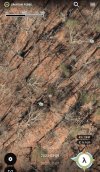
Not sure about the desktop version, but on my phone I can click the date that the aerial was taken (at the bottom) and toggle between dozens of different aerials taken at different times of year. Some of them are so clear you could pick your tree and estimate how many sticks you'll need to get to hunting height...Screenshot_20240220-191249.jpg
 
take a listen to this if you could sir
Never heard of this podcast but I wanted to look up the episode and listen. Looks like they have a bunch of interesting topics and guests, going to give a few a listen I think. Thanks for the suggestion.
 
Not sure about the desktop version, but on my phone I can click the date that the aerial was taken (at the bottom) and toggle between dozens of different aerials taken at different times of year. Some of them are so clear you could pick your tree and estimate how many sticks you'll need to get to hunting height...View attachment 100029

Rope climbing there, lol
 
Making me want to look at Huntstand more.

On topic I used, sorry ran, OnX and Spartan Forge both last year. Each had things I enjoyed but like @Andrew920 said I’m probably going back to just OnX. I’m also
really rooting for SF to succeed though so I may continue the subscription. Feel like they have some really good things going for deer hunting, I’ll end up at one or none though at some point.
 
SF map quality varies depending on the part of the state or country you’re looking at. I can see clear differences in my region big time. I thought I remember Bill (creator of SF) say they’re going to move their stuff to all private servers and continue to add to the map quality, including potential drone work they’re going to invest in. Personally I am going to stick with them. They’re going to add some really cool stuff as time goes on and they already have comparing from where they started.

That said, I am also going to continue to run HS too. There’s things I like/don’t like about both and with both available to play with, I’m happy.
 
Taking a stab in the dark that he’s using pictures for comparison sake and not to show folks where he hunts. Thats how I took it.

Dang, he gets nice bucks. So that’s not the honey hole? lol.

Honestly, don’t know the first thing about these apps. Is there one that gets me home best where there is no cell service?
 
Dang, he gets nice bucks. So that’s not the honey hole? lol.

Honestly, don’t know the first thing about these apps. Is there one that gets me home best where there is no cell service?
All of them have the ability to download offline maps. Haven’t used that much. Did on HuntStand once and it worked fine.
 
Y’all come on down and I’ll do a free guided hunt on some spikes. Whenever I go from HS or OnX to SF, it’s like my phone gets cateracts. The only reason I keep it is the 3d and lidar map.


Sent from my iPhone using Tapatalk
 
Last edited:
You have to remember these apps are not pulling imaging from a single source for the nation. It’s thousand and thousands of arial surveys, sat imagery, and (in SF case) UAV imagery. Yes it varies in quality with regions based on availability, weather when it was taken, modality etc. but what I look for, as stated above, is multiple different images and dates available for a given area to be available in an app. In this regard, SF dominates at the moment. Imagery resolution difference between apps is constantly in flux as areas are updated, which is usually done in an automated fashion since no one can manually review every county and survey in the nations
 
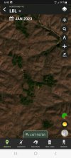
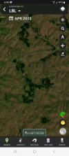
One thing I like in Hunt Stand is the monthly satellite views.
This area in Jan 2023 showed pines or cedar trees.
Screenshot_20240221_064019.jpg

The same area in April showes first trees and brush to green up.
Screenshot_20240221_064056.jpg
 
Back
Top