Yep. Some of us at spoiled with broken tracks of land vs areas that are seemingly homogeneous.The more I read everyone’s input the more I realize how incredibly specific our approaches are to the region we are hunting…
-
The SH Membership has gone live. Only SH Members have access to post in the classifieds. All members can view the classifieds. Starting in 2020 only SH Members will be admitted to the annual hunting contest. Current members will need to follow these steps to upgrade: 1. Click on your username 2. Click on Account upgrades 3. Choose SH Member and purchase.
-
We've been working hard the past few weeks to come up with some big changes to our vendor policies to meet the changing needs of our community. Please see the new vendor rules here: Vendor Access Area Rules
You are using an out of date browser. It may not display this or other websites correctly.
You should upgrade or use an alternative browser.
You should upgrade or use an alternative browser.
Speed scouting vs scouting thoroughly on new pieces? How to be more efficient?
- Thread starter greg728
- Start date
100% trueThe more I read everyone’s input the more I realize how incredibly specific our approaches are to the region we are hunting…
To me, if an area is totally homogeneous id strike the whole enchilada off my list. I only hunt two habitats anymore, swamps and mountains. Any big tracks of woods with swamps I go right to the water and dense cover. Mountains I look for the green mtn laurel that pops out in Onx and thick saplings. Even if some vegetation is harder to see on certain tracts you can easily cross off all the worthless wide open woods and where you expect most hunters to be.Yep. Some of us at spoiled with broken tracks of land vs areas that are seemingly homogeneous.
How does mountain laurel stand out to you on onx? I’m new to mountain hunting and know it provides good cover but I’m not sure how to identify it from the app.To me, if an area is totally homogeneous id strike the whole enchilada off my list. I only hunt two habitats anymore, swamps and mountains. Any big tracks of woods with swamps I go right to the water and dense cover. Mountains I look for the green mtn laurel that pops out in Onx and thick saplings. Even if some vegetation is harder to see on certain tracts you can easily cross off all the worthless wide open woods and where you expect most hunters to be.
All that green stuff just pops. Can't miss itHow does mountain laurel stand out to you on onx? I’m new to mountain hunting and know it provides good cover but I’m not sure how to identify it from the app.

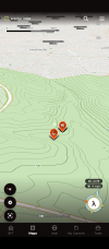
Thanks man I think I just assumed that was all hemlocksAll that green stuff just pops. Can't miss it View attachment 102248
Hemlocks are usually much more defined like these.Thanks man I think I just assumed that was all hemlocks

Slow, meticulous scouting post season up until spring green up. There's nothing like boots on the ground.
But speed scouting just before the season in order to confirm that there's been no major changes.
A lot can happen between April and October.
One thing we are dealing with around here is the loss of healthy, standing trees. Like a lot of places, we've lost pretty much every ash tree but something seems to be going on with black cherry trees too. I can't believe how many are up-rooted in our woods. An 80 foot tall tree that's no laying on the ground can shift deer movement just far enough make a stand useless for a bowhunter.
It's almost to the end of the time frame for shed hunting, morel picking, general reconnaissance, and adjusting presets. I'm blown away at just how many trees are either dead, dying, or are laying on the ground. Some of this die-off has been long term like what happened to the ash trees so it's been an on going adjustment to patterns and stand placement. But this thing with the cherry trees is a newer phenomena. I used to know the couple hundred acres behind my home like the back of my hand but in the last 6-10 years the deer patterns have changed drastically.
So get out now and pound every acre and devise all your schemes. But get back out and do some low disturbance, speed scouting just prior to the season.
@greg728 This isnt a dissenting opinion to what has been posted, just trying to come at the question from a different perspective. Like @Jammintree mentioned there are tons of ways to skin the cat and depending where we are tactics or strategies can very from very little to whole lot. Early on all of my scouting was slow and methodical but as tech has improved and my general deer knowledge has grown, it's now a sorta hybrid speed/methodical approach. If I am looking at a new chunk of ground, around here it is likely big chunks of big timber public, I am going to e-scout it using topo, lidar and aerial maps. Deer need food, water, bedding cover and sex. In my opinion, understanding food is the most important aspect. Primary food sources are cyclical through the season and as they shift and change, it can impact travel from bed to food and travel for sex because the does have moved or are travelling differently. Knowing where the primary food is will point us towards the highest odds terrain or vegetative features deer will use to move across the landscape. E-scouting a new piece I drop pins on flats or benches where I expect to find primary feeding areas, here its white or red oaks. I am going to do that at different elevations using topo and then start looking at aerial and lidar maps for edges or terrain features coming into those feed areas and drop pins on those spots. What I am really looking for are those spots where a buck is going to walk but not leave a bunch of sign and also off of the most obvious features like saddles. In other words I want to pin and speed scout the obvious stuff for confirmation but ideally I want to hunt off of those spots if I can narrow down where THE spot is. Thats where I am going to slow down is between the pins, looking for that 20 yard circle that I think a buck will put his feet in. Find those spots without a bunch or any sign and you have found gold cause virtually no one else will ever be there except you and the bucks you want to shoot. And there are higher than avg odds those spots will produce year after year. Think about the season as a progression of small cyclical changes, scout and plan your hunts accordingly and hunt 'em where they least expect it and no one else has figured out.
Or you can keep it super simple if you just want to kill some deer and hunt the primary food throughout the season. That's fun too!!
Or you can keep it super simple if you just want to kill some deer and hunt the primary food throughout the season. That's fun too!!
Thanks man. I found it pretty tough hunting food sroubd me because it’s everywhere and the deer browse a ton. I do try to look for isolated oaks and vegetation that’s been mowed down near bedding or staging areas though. On another note, how much different intel can you get from LiDAR than other maps? It seems to be the thing everyone is talking about but I’ve never seen or used it.@greg728 This isnt a dissenting opinion to what has been posted, just trying to come at the question from a different perspective. Like @Jammintree mentioned there are tons of ways to skin the cat and depending where we are tactics or strategies can very from very little to whole lot. Early on all of my scouting was slow and methodical but as tech has improved and my general deer knowledge has grown, it's now a sorta hybrid speed/methodical approach. If I am looking at a new chunk of ground, around here it is likely big chunks of big timber public, I am going to e-scout it using topo, lidar and aerial maps. Deer need food, water, bedding cover and sex. In my opinion, understanding food is the most important aspect. Primary food sources are cyclical through the season and as they shift and change, it can impact travel from bed to food and travel for sex because the does have moved or are travelling differently. Knowing where the primary food is will point us towards the highest odds terrain or vegetative features deer will use to move across the landscape. E-scouting a new piece I drop pins on flats or benches where I expect to find primary feeding areas, here its white or red oaks. I am going to do that at different elevations using topo and then start looking at aerial and lidar maps for edges or terrain features coming into those feed areas and drop pins on those spots. What I am really looking for are those spots where a buck is going to walk but not leave a bunch of sign and also off of the most obvious features like saddles. In other words I want to pin and speed scout the obvious stuff for confirmation but ideally I want to hunt off of those spots if I can narrow down where THE spot is. Thats where I am going to slow down is between the pins, looking for that 20 yard circle that I think a buck will put his feet in. Find those spots without a bunch or any sign and you have found gold cause virtually no one else will ever be there except you and the bucks you want to shoot. And there are higher than avg odds those spots will produce year after year. Think about the season as a progression of small cyclical changes, scout and plan your hunts accordingly and hunt 'em where they least expect it and no one else has figured out.
Or you can keep it super simple if you just want to kill some deer and hunt the primary food throughout the season. That's fun too!!
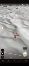
The LIDAR is great for seeing elevation changes. Great for finding shelves , gaps between ridges, slight depressions. You can see some of that on topos depending on the scale of the map and how fine the steps are. On the apps, 20ft is the steps so you can lose a lot of topographical detail just relying on topos to find fine detail
Last edited:
Good to know. I’ve blown up topo maps and went in to scout not realizing there was elevation change. You use the premium onx to view this?The LIDAR is great for seeing elevation changes. Great for finding shelves , gaps between ridges, slight depressions. You can see some of that on topos depending on the scale of the map and how fine the steps are. On the apps, 20ft is the steps so you can lose a lot of topographical detail just relying on topos to find fine detail
I use Spartan forge dunno what onX hasGood to know. I’ve blown up topo maps and went in to scout not realizing there was elevation change. You use the premium onx to view this?
- Joined
- Jan 5, 2021
- Messages
- 2,199
My state has an online lidar resource open to the public. Yours might also.Good to know. I’ve blown up topo maps and went in to scout not realizing there was elevation change. You use the premium onx to view this?
To me its the difference in 24" analog TV and 4k on an 85" flat screen. With a topo, I would mark an area. Sometimes it might be as small as an acre depending on the terrain feature I am looking at. With Lidar, I am marking spots the size of my truck in a lot of cases.Thanks man. I found it pretty tough hunting food sroubd me because it’s everywhere and the deer browse a ton. I do try to look for isolated oaks and vegetation that’s been mowed down near bedding or staging areas though. On another note, how much different intel can you get from LiDAR than other maps? It seems to be the thing everyone is talking about but I’ve never seen or used it.