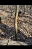
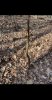
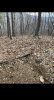
Went out to a new piece of public land in the Appalachian Mountains today to scout areas I marked using LiDAR data on CalTopo and stuff I’ve picked up from forums like these. Understanding it’s out of season and deer migrate/sign changes, it was nice to see some of the e-scouting pay off, as I believe I found a trail of old and new rubs guided by fresh deer tracks and ultimately leading to a nice sized single bed towards the higher elevations of a southeastern slope. Several elevation bands lower, there were a ton of doe beds and scat all through mountain laurel. It’s cool to see the sign, I just need to get out more and try and figure how to put it all together.
-
The SH Membership has gone live. Only SH Members have access to post in the classifieds. All members can view the classifieds. Starting in 2020 only SH Members will be admitted to the annual hunting contest. Current members will need to follow these steps to upgrade: 1. Click on your username 2. Click on Account upgrades 3. Choose SH Member and purchase.
-
We've been working hard the past few weeks to come up with some big changes to our vendor policies to meet the changing needs of our community. Please see the new vendor rules here: Vendor Access Area Rules
Winter Scout Session
- Thread starter 515Raven
- Start date