The only thing I like about Spartan Forge is LiDar. Soon as Huntstand adds that, I'll drop SF. Part of it is probably just a decade of familiarity, but I really do believe they have some basic functionality that SF overlooks in a rush to do new things.
-
The SH Membership has gone live. Only SH Members have access to post in the classifieds. All members can view the classifieds. Starting in 2020 only SH Members will be admitted to the annual hunting contest. Current members will need to follow these steps to upgrade: 1. Click on your username 2. Click on Account upgrades 3. Choose SH Member and purchase.
-
We've been working hard the past few weeks to come up with some big changes to our vendor policies to meet the changing needs of our community. Please see the new vendor rules here: Vendor Access Area Rules
You are using an out of date browser. It may not display this or other websites correctly.
You should upgrade or use an alternative browser.
You should upgrade or use an alternative browser.
Spartan Forge Rant
- Thread starter Rutman
- Start date
- Joined
- Jan 3, 2022
- Messages
- 4,268
I use Onx for the broad strokes but boots on the ground trumps everything. To get out in the dark I make sure to have a compass and I mostly use a Garmin GPS 64st. I find it way more reliable than the phone, but I verify with the compass occasionally. The phones are getting more reliable.Dang, he gets nice bucks. So that’s not the honey hole? lol.
Honestly, don’t know the first thing about these apps. Is there one that gets me home best where there is no cell service?
OnX Elite is progressively adding features as well, although it's more restricted for the single-state user...
I was disappointed with the quality as well. It does seem dependent on your area. Hunstand has more up to date satellite imagery for me right now. It’s from this past summer.
Homebrew454
Well-Known Member
I used Onx in Colorado with the offline mapping feature and it worked great. As previously stated, I think they all have offline maps. Onx allows you to chose how good of quality you want the offline maps to be. I did 2 versions (user set) 5 mile x 5 mile and 10 mile by 10 mile.Dang, he gets nice bucks. So that’s not the honey hole? lol.
Honestly, don’t know the first thing about these apps. Is there one that gets me home best where there is no cell service?
I've messed with SF free version and bought HS a year ago. I just prefer the Onx user interface.
Sent from my SM-S911U using Tapatalk
- Joined
- Sep 14, 2020
- Messages
- 5,966
I use Onx for the broad strokes but boots on the ground trumps everything. To get out in the dark I make sure to have a compass and I mostly use a Garmin GPS 64st. I find it way more reliable than the phone, but I verify with the compass occasionally. The phones are getting more reliable.
I’ll have to try it out. I have some free Onx Elite from my K4 purchase.
I’ve just been using a compass but could use a backup. I tried a Garmin several years ago and it didn’t get a reliable signal. And things got wonky with the compass one time…I finally put 2 and 2 together that magnetic closures in my glomitts were causing interference. Duh.
- Joined
- Sep 27, 2018
- Messages
- 3,927
I like SF much better that the other two and will keep it. Below is an example of where the quality of aerials collide….

This isn’t an issue for me because I have access to statewide aerials that are incredible.
Case in point….


Yes, those are deer trails in the bottom photo, lol. I actually used that imagery to go in there blind (just S of the area shown) and bumped a really nice buck 60 yds from THE tree I was heading to.
The SF imagery will catch up, but fortunately most of the areas I hunt in have good aerials already.

This isn’t an issue for me because I have access to statewide aerials that are incredible.
Case in point….


Yes, those are deer trails in the bottom photo, lol. I actually used that imagery to go in there blind (just S of the area shown) and bumped a really nice buck 60 yds from THE tree I was heading to.
The SF imagery will catch up, but fortunately most of the areas I hunt in have good aerials already.
- Joined
- Jan 3, 2022
- Messages
- 4,268
I have to say I have been happy with Onx. The few issues I had were with using an older Iphone (6) and they updated the system and there were compatibility issues. When I called customer support they were very helpful and even comped me a month or two and it was the older phone anyway. I'm frugal (cheap) and won't upgrade Iphones until they make me, lol, and only then take my wife's older Iphone and she gets the new one.I’ll have to try it out. I have some free Onx Elite from my K4 purchase.
I’ve just been using a compass but could use a backup. I tried a Garmin several years ago and it didn’t get a reliable signal. And things got wonky with the compass one time…I finally put 2 and 2 together that magnetic closures in my glomitts were causing interference. Duh.
If you are going that route, check to make sure the platform is supported if you are running an older phone.
I've been pretty happy with Onx too. I just ran into an issue where I can't import any more data though. I can keep creating stuff but it tells me I'm over my limit when I try to import something. I have to figure out what I'm going to do going forward because it will be a pain to have to go through and delete stuff. I like the convience of everything on my phone but as far as waypoint and track management I miss doing it all in an app on my computer where I could do stuff in batches. I've been backing up my onx data so I don't loose it but having to move it over to manage it kinda defeats the point.I have to say I have been happy with Onx. The few issues I had were with using an older Iphone (6) and they updated the system and there were compatibility issues. When I called customer support they were very helpful and even comped me a month or two and it was the older phone anyway. I'm frugal (cheap) and won't upgrade Iphones until they make me, lol, and only then take my wife's older Iphone and she gets the new one.
If you are going that route, check to make sure the platform is supported if you are running an older phone.
Homebrew454
Well-Known Member
Is it an issue with your phone's storage or the app? I have some data in 3 different states and offline maps in all of the states. Don't want to lose it.I've been pretty happy with Onx too. I just ran into an issue where I can't import any more data though. I can keep creating stuff but it tells me I'm over my limit when I try to import something. I have to figure out what I'm going to do going forward because it will be a pain to have to go through and delete stuff. I like the convience of everything on my phone but as far as waypoint and track management I miss doing it all in an app on my computer where I could do stuff in batches. I've been backing up my onx data so I don't loose it but having to move it over to manage it kinda defeats the point.
Doubt I have a many waypoints as you though.
Sent from my SM-S911U using Tapatalk
I’ve come out with a few new apps called PayPal friends and family, Venmo and Zelle, You just have to pay 19.99 / month. It will absolutely give you information you can’t find anywhere else. Or if you want a beta version of the new features you can pay 29.99/month and I will email you in a few years when I invent them. Best new app on the market. Get in now while the prices are low.
I can’t believe this guy is still in business.
I can’t believe this guy is still in business.
No it's the app. I think it said it was limited to 3500 data points. I mark a lot of stuffIs it an issue with your phone's storage or the app? I have some data in 3 different states and offline maps in all of the states. Don't want to lose it.
Doubt I have a many waypoints as you though.
Sent from my SM-S911U using Tapatalk
Homebrew454
Well-Known Member
Gotcha. I started out marking a lot of stuff. But then it got to be too many points in small area. Mainly mark beds rubs scrapes. I used to walk game trails marking them but only do that in great areas now.No it's the app. I think it said it was limited to 3500 data points. I mark a lot of stuff
Sent from my SM-S911U using Tapatalk
I use HuntStand for all my hunting data collection (setups, deer tails, bedding, etc.) and have been pretty happy with it. The Google maps default on HuntStand is pretty good where I hunt so I'm happy with its imagery. Where it lacks in my opinion is the same as @Nutterbuster pointed out . . . LiDar data.
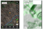
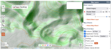
Since I navigate primarily by terrain features this LiDar data is very useful for me. For that I use the basic free CalTopo app. By adding two base layers I can toggle between the LiDar and Satellite imagery and the LiDar imagery provides incredible definition. The first two pictures are screenshots from my phone from HuntStand and CalTopo respectively of the same spot. Blue line is a walked while recording deer trail.


Since I navigate primarily by terrain features this LiDar data is very useful for me. For that I use the basic free CalTopo app. By adding two base layers I can toggle between the LiDar and Satellite imagery and the LiDar imagery provides incredible definition. The first two pictures are screenshots from my phone from HuntStand and CalTopo respectively of the same spot. Blue line is a walked while recording deer trail.


Last edited:
I have generally found OnX to be consistently most usable for aerial in my area. Supplement with CalTopo for LIDAR and negative imagery, GIS if I really wanna get granular. SF had cool stuff but the UI for waypoints and routes was too clunky for my taste.

