• The SH Membership has gone live. Only SH Members have access to post in the classifieds. All members can view the classifieds. Starting in 2020 only SH Members will be admitted to the annual hunting contest. Current members will need to follow these steps to upgrade: 1. Click on your username 2. Click on Account upgrades 3. Choose SH Member and purchase.
  • We've been working hard the past few weeks to come up with some big changes to our vendor policies to meet the changing needs of our community. Please see the new vendor rules here: Vendor Access Area Rules

need help 2 day hunt strategy big oak flat

Will Harris

Well-Known Member
SH Member
Joined
Sep 26, 2018
Messages
415
Location
Indiana
i got drawn for a 2 day hunt. the section i drew is a 1mile x 0.5 mile section that is a big oak flat and some drainages. the only access is on the southern end and its 0.5mile long. the northern end is bounded by a river. the east side is 1 mile and there are other hunters on it. the west side cannot be hunted and it is mostly drop offs down to a lower level. there is no ag anywhere close.

so this is really a big oak flat. most of the akerns are gone and the rut is on. no idea about any food sources. onx doesnt show any. so i assume only greenbriar and other such as that. previous harvest data shows low deer density or bad hunters, so i assume low density.

i can shoot up to 4 deer, 2 of which can be bucks. medium sized doe would be just fine with me.

this place gets hunted only on the wkends so no one will have been in there for at least 5 days. there are 3 other guys in this area.

i assume the "find bedding and pinchpoints/travel corridors and hunt the downwind side of those" strategy. anyone else with big, mostly monotonous terrain experience have any better ideas?

thanks for any help.
 
I'd look for edges. Spots on aerial photos that show texture/change.

Onx stinks at that.

I'd get on Google Earth and use the "way back machine" slider doohickey and review all available images. You can see changes happening that way that gives you a clue to what is there now. Also, leaf off pics are good and if it snows where you are at then snow pics can show a lot.

PS more soft edges...2 different forest densities meeting or 2 different forest types meeting
 
I'd look for edges. Spots on aerial photos that show texture/change.

Onx stinks at that.

I'd get on Google Earth and use the "way back machine" slider doohickey and review all available images. You can see changes happening that way that gives you a clue to what is there now. Also, leaf off pics are good and if it snows where you are at then snow pics can show a lot.
Google earth is still better but onx added more imagery where you can view it without the canopy so it is better at least.

To the OP, I agree. You need to find edges the bucks with be cruising or terrain that funnels them into a spot. Then get in a tree and sit there the entire 2 days. Don't leave for lunch.

I always left for lunch in the past. I stopped doing that during the rut. Now, I see bucks get up and cruise from 11 am to 1 pm all the time.
 
I always left for lunch in the past. I stopped doing that during the rut. Now, I see bucks get up and cruise from 11 am to 1 pm all the time.
I forget where I said this on here but last time I was in a tree I was reflecting on the times I killed all my bucks. Between Nov 1 and 19th I have NEVER killed a buck outside of 9:30am-2:30pm. !!! I think I mentioned it wherever I said that I am not even worried about having to drop my girls off at school and head to the woods then head home to be with them. The rut is actually the perfect time for that!
 
looking at lidar images may help you identify small terrain funnels before you get boots on the ground, can you scout in person or no access until opening day?
 
If I have open woods, all to myself, and a gun, I’m leaving my saddle in the backpack. And I’m wearing my comfy boots…
 
looking at lidar images may help you identify small terrain funnels before you get boots on the ground, can you scout in person or no access until opening day?

where are you getting lidar? i think it could be used to determine edges also

i used to mess with that stuff in a past life, but now i'm out of the loop and no longer have licenses for the pro software (ESRI)
 
spartan forge has lidar

interesting tidbit....it's probably heavily down-sampled....I had access to full resolution before and I could count the steps on my parent's front porch
 
interesting tidbit....it's probably heavily down-sampled....I had access to full resolution before and I could count the steps on my parent's front porch
I've never seen full res lidar, but it provides more "texture" than the 10ft contours will show
 
I've never seen full res lidar, but it provides more "texture" than the 10ft contours will show

the original resolution is like 1 or a few inches....that laser really hits like a sewing machine from space

funny that we've probably all been hit by a space laser and didn't even know it.....
 
the original resolution is like 1 or a few inches....that laser really hits like a sewing machine from space

funny that we've probably all been hit by a space laser and didn't even know it.....
IIRC Bill said 5 inches. Little ridges I know well in the bottoms that are at most 12-18" higher than surrounding areas jump out on the images.
 
thanks to all that replied. it was a fun and productive wkend and good lessons on low density deer areas during rut.

Aerial imagery was not helpful as this is a big block of oak monotony. google earth images all for the past few years were only taken in the late summer. topography was my only help. i contemplated the accesses, took into account the 7 previous hunts that had taken place here and went deep and light.

that put me in the neighborhood, but not on the X. boots on the ground was the next step. we know they follow rivers and they want to get downwind so thats where i went next. rushed a shot on a 10ptr and only gave him a haircut. no meat or blood. more hunt/scouting and i got into good sign. i bumped a deer off bed and continued hunt/scouting. by late afternoon, i set up over the bed and an hour later a doe was headed for that area and i shot her.

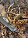
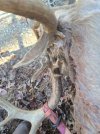
the next morning i went to an area that had good sign and appeared on the travel routes that a buck would take when he was looking for love. by 8:30 i was second guessing myself and got up to hunt/scout. 50 yds from where i was sitting, he walked right to me. he has really cool character that you can only see from behind.

72209451460__610D8DD8-F4B7-4C01-8F96-77827EC5D4B1.jpgResized_20231119_121913.JPEG72209451460__610D8DD8-F4B7-4C01-8F96-77827EC5D4B1.jpg
 
Back
Top