- Joined
- Jun 28, 2019
- Messages
- 8,141
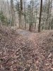
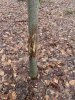
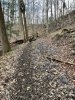
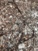
I got out yesterday and scouted a section of public that I've always wanted to check out but never have. I think it was productive. I found a lot of deer sign in the form of beaten down trails and a decent sized rub facing the ridge so I'm assuming the buck made the rub in the evening as it was heading out from the ridge but who knows.
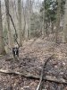
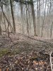
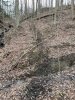
These logging roads are on the south side of the slope and there are some nice benches below the ridge top. Pressure is on the top during the season, and I've been hunting side hills a lot more over the last few years but Its always hard trying to figure out where exactly and how exactly to hunt this kind of sign.
All of the old logging roads had beaten down deer trails on them and all of them came up to the ridgeline along the continuity of its length with the main ridge running east-west. So why do they use all of the roads seemingly equally and how do you determine which ones to hunt on any given day? Without a shotgun of trail cams on each old logging road (which I may still do), The only thing I can think of is that a buck is going to use the most downwind trail or location on any given day depending on the wind direction for that day so he can scent check as much of the area he's going to eventually go through or skirt as much as possible. Like I explained earlier, all of these old logging roads and benches are on the south facing slopes of a generally east to west running ridgeline.
So my logic is if the wind is going to be from the extreme west, that buck will probably use the east most trail as its traveling northward toward daylight activity so it can smell a majority of the area as it travels toward evening feeding. Likewise, on its return trip to the south facing slopes to bed for the day, It will also use the east most trail to enter the sidehill area to bed, then hooking around so the wind is over its back from the west. As the wind changes angle to this ridge, they will change which roads they use to try and always be able to scent check a majority of the cover they will be heading through.
If my assumptions are correct, then all of the continuous activity on all of these trails seems to make sense. Wondering what your thoughts are about this and how you would choose actual hunting locations in this kind of terrain?