- Joined
- Jan 3, 2022
- Messages
- 4,310
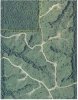
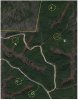
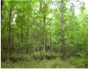
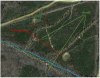
Thanks. I hope it helps. Here is another analysis of a block of pines on a club I broke down for a friend of mine. The first aerial is from Google Earth in 2007 showing about a year or so of regrowth. In this picture you can clearly see what Weldabeast was talking about when he was referring to the landings. These are the spots the loggers drag the logs up to so they can be loaded on the trucks. The second picture is from early 2021. A lot of the detail that was visible in the first picture has been lost. Circled in yellow are the locations of the old skidder landings. The green lines are the old skidder lanes. The red dotted lines show the SMZ's, the low spots along the creeks where the loggers left the trees. Pay special attention to where two creeks meet up.
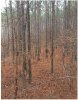
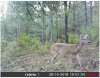
I like to walk all the SMZ's and look for sign and mast bearing trees (oaks, persimmons) and look for rubs and scrapes. On this block, I would expect the best buck sign to be concentrated on the spots designated A through E. These are the old skidder lanes leading down to the old landings. These spots will be thick but slightly more open than the surrounding pines. It would not surprise me one bit if one or more of these spots held a primary scrape.
I like to walk all the SMZ's and look for sign and mast bearing trees (oaks, persimmons) and look for rubs and scrapes. On this block, I would expect the best buck sign to be concentrated on the spots designated A through E. These are the old skidder lanes leading down to the old landings. These spots will be thick but slightly more open than the surrounding pines. It would not surprise me one bit if one or more of these spots held a primary scrape.