-
The SH Membership has gone live. Only SH Members have access to post in the classifieds. All members can view the classifieds. Starting in 2020 only SH Members will be admitted to the annual hunting contest. Current members will need to follow these steps to upgrade: 1. Click on your username 2. Click on Account upgrades 3. Choose SH Member and purchase.
-
We've been working hard the past few weeks to come up with some big changes to our vendor policies to meet the changing needs of our community. Please see the new vendor rules here: Vendor Access Area Rules
You are using an out of date browser. It may not display this or other websites correctly.
You should upgrade or use an alternative browser.
You should upgrade or use an alternative browser.
Spartan Forge Platform Now Offers LIDAR
- Thread starter BackSpasm
- Start date
If your state had such imaging available, how would one go about finding it?Fyi- depending on your state, you might have access to free lidar imagery.
Sent from my Pixel 3 using Tapatalk
https://lidarandaerialarchaeology.com/north-america/If your state had such imaging available, how would one go about finding it?
Sent from my Pixel 3 using Tapatalk
This page has a bunch of links
Y'all riddle me this.
3 times I've had the app crash in a specific location under some large power lines. It runs fine everywhere but there. Once it crashes at that location, it will keep crashing until you reinstall it.
Coinkydink, or is there something that could make it crash in a specific area? Lack of satellite/cell signal?
To give it credit, I found 3 new wood duck holes and hog highways in the swamp thanks to being able to pick up on very, very subtle ridges in the swamp. It's incredible how detailed lidar is.

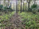
Above is a ridge in a swamp, with a small ditch running it. Not sure if it's a random water channel or (suspected) the remnants of an old primitive road. Pretty clearly defined.

Above is the in-person view of that ditch. The ridge is maybe 2-3ft higher than the surrounding swamp. The ditch is maybe a foot or 2 deep.
If you hunt swamps, LiDar is the biggest thing that's ever happened for your hunting.
How does the detail in spartan Forge compare to CalTopo's shaded relief for this particular feature? I'm comparing the two currently and it looks like caltopo had better detail?View attachment 95827
Above is a ridge in a swamp, with a small ditch running it. Not sure if it's a random water channel or (suspected) the remnants of an old primitive road. Pretty clearly defined.
View attachment 95828
Above is the in-person view of that ditch. The ridge is maybe 2-3ft higher than the surrounding swamp. The ditch is maybe a foot or 2 deep.
If you hunt swamps, LiDar is the biggest thing that's ever happened for your hunting.
I left the coordinates on the image. Post up whatever caltopo shows. It's been years since I've messed with it so I'm not sure. But if it shows more detail than this, I'll swap.How does the detail in spartan Forge compare to CalTopo's shaded relief for this particular feature? I'm comparing the two currently and it looks like caltopo had better detail?
This doesn't look to be much different to my eye, maybe a touch more detailedI left the coordinates on the image. Post up whatever caltopo shows. It's been years since I've messed with it so I'm not sure. But if it shows more detail than this, I'll swap.

Sent from my Pixel 3 using Tapatalk
Not much functional difference in image quality to my eye.This doesn't look to be much different to my eye, maybe a touch more detailed
Sent from my Pixel 3 using Tapatalk
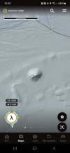
Post this up if you've got time:

To give some perspective, the indentation in the mound just to the lower-left of the cross hair is the remnants of where they excavated and then filled in an archeological dig on the mound. It's not much bigger than a bathtub.
The ditch that runs east-west just north of the mound is a foot trail. Literally just a 6" to 1' depression made by people walking in to sight see.
A little more detail, and that's CalTopos free version, not sure if the pro would offer even more detail or notNot much functional difference in image quality to my eye.
Post this up if you've got time:
View attachment 95841
To give some perspective, the indentation in the mound just to the lower-left of the cross hair is the remnants of where they excavated and then filled in an archeological dig on the mound. It's not much bigger than a bathtub.
The ditch that runs east-west just north of the mound is a foot trail. Literally just a 6" to 1' depression made by people walking in to sight see.

Sent from my Pixel 3 using Tapatalk
deertrout
Well-Known Member
I have the caltopo pro and that feature looks the same as the free.
I caved and downloaded spartan forge this year. I actually really like it. As a hillcountry hunter, I'm not ready to dump caltopo but I won't renew the pro version next year,just going to run the free.
This was my first season in about 5 years not using onx, the only time I missed it was when I needed to share pins with friends who only have onx. Slowly converting them to SF, does that make me an influencer?
TRanegar26
New Member
- Joined
- Dec 7, 2023
- Messages
- 6
I use ONX, SF, HUNTWISE - all have their perks. I use each app differently (scouting, specific trees, signs).
Really like SF for their UAVS and lidar, but it's not perfect.
Really like SF for their UAVS and lidar, but it's not perfect.


