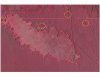
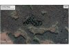
alright, i want to test my aerial skills here on another marsh parcel.
here's an aerial:

and in false IR:

so I would have mapped out these routes and areas to walk when I go out to scout:

the E/W lines on the east side of the slough definitely trace transitions in the timber, looking like it goes from a cypress-tupelo swamp nearest to the road to more hardwoodsy looking area.
to the west of slough, again, there's a line that looks like the edge of a swamp meeting more hardwoods, and the circled area looks like woods with the drainage cutting into it.