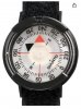
I spent my callow youth on the bridge of USCG cutters. As you might expect, navigating at sea has been the object of human ingenuity for centuries. Even with GPS units, LORAN-C, and gyrocompass repeaters, we still use the ship's magnetic compass as the standard against which all the techy-techy tools are compared. "Steering 158 True, check 163 Magnetic". And we would check the accuracy of our magnetic compass by comparing it to the heading of the pier to which we were tied. So, if you're on a north-south section line or whatever, you can check your compasses to confirm. Or if you happen to notice your gear is telling you the sun is setting in the South, you know you have something to resolve. A decent Silva orienteering compass takes up very little space in a bino pack or kill kit, takes no batteries, and is generally reliable in the absence of magnetic interference. If you're in a junkyard or old iron ore mine you'll want to use other references. Personally, I would rather leave my phone in my pocket (saving the batteries and avoiding distractions) and use an analog compass rather than a gizmo. I'm no luddite - I still carry a phone and Garmin Rino afield and geek out over GIS tools - but the paper maps and magnetic compasses like Lewis and Clark used, still work just as well today.